
|
Navigation: Home Page About UK Postcodes Find a Postcode Postcode Areas Info Find Distances Counties Information Useful Links Australian Postcodes |
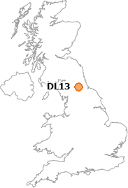
DL13 Postcode Information
• Towns/Areas in DL13:
Bedburn, County Durham
Burnt Houses, County Durham
Butsfield, County Durham
Cockfield, County Durham
Copley, County Durham
Cowshill, County Durham
Crawleyside, County Durham
Daddry Shield, County Durham
East Hedleyhope, County Durham
Eastgate, County Durham
Frosterley, County Durham
Hamsterley, County Durham
Hill End, County Durham
Ireshopeburn, County Durham
Low Redford, County Durham
Rookhope, County Durham
Satley, County Durham
St John's, County Durham
St John's Chapel, County Durham
Stanhope, County Durham
Sunniside, County Durham
Thornley, County Durham
Tow Law, County Durham
Wearhead, County Durham
Westgate, County Durham
Wolsingham, County Durham
Woodland, County Durham

• Find distances between DL13 and any other postcode
• DL13 local information
(Hotels, Transport Links, Geographical Features etc)
• Find hotels and guest houses in DL13
(courtesy of SmoothHound)
• Go back to previous page
| Copyright © 2005-2026 postcode-info.co.uk | Privacy Policy | page created in 0.011 seconds |